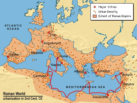

Here is a map of the Roman Empire around the 2nd Century CE. In red is one of the possible routes Ignatius sailed under Roman guard on the way to Rome for his trial and subsequent execution. This particular route was suggeted from: The Times of Ignatius, by Patrick Henry Reardon. The winding route enabled the Roman guards to stop as several ports and pick up more prisoners as they made their trip back to Rome. Undoubtedly, by the time the boat arrived in Rome, it was full of prisoners. Click on the red line to learn more about the sea routes of this time period.
The blue line represents the land travel Ignatius took from the port to Rome. Since the city of Rome is landlocked, Ignatius probably traveled over some land. The Romans had an extensive infrastructure of well built and maintained roads. Click on the blue line to learn more about Roman roads.
The map above has five clickable sites: The red line takes you to the page about Roman Sea Travel, the blue line takes you to the page about Roman Roads; you can also click on the cities of Antioch and Rome, and there is a page accessible by clicking on Asia Minor, which is modern day Turkey.
This site constructed by Jacob Bradley for Dr. Robert Royalty's Religion 372 class at Wabash College in Crawfordsville, IN. Feel free to use anything on my site, just please cite the source.